|
Replies: 17
| visibility 3,682
|
Legend [16733]
TigerPulse: 100%
Posts: 16763
Joined: 8/19/04
|
Old Charleston question
Aug 10, 2020, 4:45 PM
|
|
|
|
In the 1950's my parents took a boat trip from Lake Marion to Charleston and I am trying to track down the dock and the hotel in the photo.
Anyone know where this dock is? Pic from 1950's. I assume it must be either Shem Creek or City Marina but not sure but a lot has changed in 65+ years and it's hard to identify based on the pic.
And what hotel is this? Again 1950's
TIA
|
|
|
|
 |
Legend [16733]
TigerPulse: 100%
Posts: 16763
Joined: 8/19/04
|
Re: Old Charleston question
Aug 11, 2020, 7:43 AM
|
|
anyone?
|
|
|
|
|
|
All-In [40344]
TigerPulse: 100%
Posts: 23465
Joined: 7/13/12
|
Doesn’t look like Shem Creek
Aug 11, 2020, 7:52 AM
|
|
I know that the coastline is ever changing, but that little spit with the power lines is throwing me off.
Possibly IOP marina I’ll have my wife post it on some CHS history Facebook group she’s in and probably will have an answer in minutes
|
|
|
|
|
|
All-TigerNet [10640]
TigerPulse: 100%
Posts: 9266
Joined: 12/29/06
|
Re: Old Charleston question
Aug 11, 2020, 7:56 AM
|
|
It has to be around 1957. The Chevy that they are loading is a '55 or '56' and the fins on one of the other cars would have been '57 (maybe Ford wagon). Someone will recognize the pier.
|
|
|
|
|
|
Legend [16186]
TigerPulse: 100%
Posts: 8524
Joined: 11/30/98
|
Re: Old Charleston question
Aug 11, 2020, 8:33 AM
|
|
Good question. I look forward to learning the answer.
Coming from the lakes, they would have taken the tail-race canal to the Cooper River and so come into Charleston harbor down the peninsula, past North Charleston and past the Naval Shipyard. In the background of the photo you can see a radio or tv tower across a broad expanse of water. I'd guess that tower is the one still standing on the Mt Pleasant side of the river. If that guess is correct the dock would have been sticking out into the river from the lower peninsula of Charleston and I think that means it would have been below the bridge. I don't know of an old public dock on that side of town, but there sure could have been.
I would doubt that on a trip from Lake Marion they would have gone over to Shem Creek, or around the peninsula to the current city marina if there was a dock closer to their line of travel. There are still some older motels standing on that side of towns with parking spots next to room doors that open directly to the outside.
I hope someone recalls that dock or the distinctive walls of that motel.
|
|
|
|
|
|
Orange Blooded [3290]
TigerPulse: 100%
Posts: 4049
Joined: 1/3/14
|
Re: Old Charleston question
Aug 11, 2020, 8:51 AM
|
|
Shem Creek. Looking North toward the highway. I dont think it could be anything on the peninsula.
|
|
|
|
|
|
Orange Blooded [3290]
TigerPulse: 100%
Posts: 4049
Joined: 1/3/14
|
Re: Old Charleston question
Aug 11, 2020, 9:04 AM
[ in reply to Re: Old Charleston question ] |
|
Shem Creek. Looking North toward the highway. I dont think it could be anything on the peninsula.
|
|
|
|
|
|
Legend [16733]
TigerPulse: 100%
Posts: 16763
Joined: 8/19/04
|
Re: Old Charleston question
Aug 11, 2020, 10:57 AM
[ in reply to Re: Old Charleston question ] |
|
Yep, it's a tough question. IF it is on the Cooper River it has to be fairly north of the Grace Memorial bridge built in 1929. Perhaps north of Grace bridge and south of Old Naval base, near where Macalloy use to be.
Possibly it is the city marina and that may be James Island across the river.
Things look too out of place for it to be Shem Creek.
Thanks to all who responded.
|
|
|
|
|
|
CU Medallion [65510]
TigerPulse: 100%
Posts: 33277
Joined: 12/3/03
|
Had to be at least late 1958, early 1959, because one of the
Aug 11, 2020, 8:54 AM
|
|
cars in the bottom picture is a 1959 Chevy station wagon. (Easy to recognize due to the flat batwing rear end, and the cat eye tail lights.)
|
|
|
|
|
|
Orange Blooded [4365]
TigerPulse: 80%
Posts: 8370
Joined: 1/4/17
|
Complicating Factor
Aug 11, 2020, 9:10 AM
|
|
The Ashley River Bridge was closed for a while in 56 & 57 so this dock have looked much different during the time period in the photo as there was much more water commuting around the peninsula, including a ferry for people working downtown.
https://www.westof.net/the-river-between-us/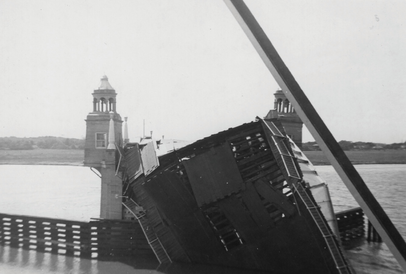 The River Between Us - West Of Remembering the time a ship crashed into the Ashley River Bridge in 1955 “It seemed to me it was going to be a pretty dull day as far as getting any news pictures was concerned. I didn’t have a single assignment for the day when I reported for work,” said Richard Burbage, who introduced his …
|
|
|
|
|
|
CU Medallion [65510]
TigerPulse: 100%
Posts: 33277
Joined: 12/3/03
|
Just from a "channel" perspective, the first thing I thought
Aug 11, 2020, 9:53 AM
|
|
of when I saw the dock picture was Shem Creek, in Mt. Pleasant.
|
|
|
|
|
|
CU Guru [1414]
TigerPulse: 87%
Posts: 1215
Joined: 10/10/11
|
|
|
|
|
|
All-In [40344]
TigerPulse: 100%
Posts: 23465
Joined: 7/13/12
|
The lack of shrimp boats in OP
Aug 11, 2020, 9:57 AM
|
|
Is what makes feel it’s not Shem Creek
|
|
|
|
|
|
Orange Blooded [3290]
TigerPulse: 100%
Posts: 4049
Joined: 1/3/14
|
Re: The lack of shrimp boats in OP
Aug 11, 2020, 11:25 AM
|
|
I think it may be further up the creek than the shrimp boats were.
|
|
|
|
|
|
CU Guru [1692]
TigerPulse: 100%
Posts: 498
Joined: 11/21/01
|
To me, it looks like the old Municipal Yacht Basin
Aug 11, 2020, 11:42 AM
|
|
|
|

Above is a postcard from the 1950s:
The Municipal Yacht Basin (center) is now Alberta Long Lake/Park. The West Point Mill housed the US Atlantic Fleet Mine Force during the 1950s. Roper Hospital (white building) can be seen across Calhoun Street from the yacht basin, flanked by the Tuberculosis Sanitarium on the left and the medical school complex (large red group of buildings--now MUSC) on the right.
|
|
|
|
|
|
Legend [16733]
TigerPulse: 100%
Posts: 16763
Joined: 8/19/04
|
Re: To me, it looks like the old Municipal Yacht Basin
Aug 11, 2020, 12:34 PM
|
|
|
|
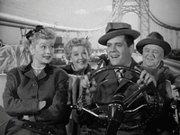
Point. I think you got it. Lockwood drive had not yet gone all the way to the Chisholm Rice Mill (now the Coast Guard Station). The basin had not been closed in yet.
Here is my mother during that trip on the left.
1950's era Partee wooden boat.
|
|
|
|
|
|
CU Medallion [65510]
TigerPulse: 100%
Posts: 33277
Joined: 12/3/03
|
Hooeee, in some backward Arab countries, those gals could
Aug 11, 2020, 12:53 PM
|
|
get thrown in jail or worse, TODAY for showing that much skin. 
|
|
|
|
|
|
All-In [40344]
TigerPulse: 100%
Posts: 23465
Joined: 7/13/12
|
Nice work!
Aug 11, 2020, 2:51 PM
[ in reply to To me, it looks like the old Municipal Yacht Basin ] |
|
My CHS history group on buddy boom said that you are right.
There’s a little tidal pond by Lockwood and Barre and Mason Prep
Nobody identified the hotel though, sorry OP
|
|
|
|
|
|
Replies: 17
| visibility 3,682
|
|
|